Last week I took Mojo to Alice Lake Provincial Park as the weather was still great and it was a nice change of scenery.
The park is situated immediately north of Squamish, so about 50 minutes drive from home and along the beautiful Sea-to-Sky Highway.
The park is set back a couple of kilometers off the main road. The entrance to the park.

I wanted to do two of the walks in the park. DeBecks Hill to get some good exercise uphill and the views at the top and then the Four Lakes Trail which was easier going and had the water stops for Mojo. A total of about 11km which was ample in this hot weather.
We take the first trail up DeBecks Hill, the trail is made from an old logging road.
 This trail is not long in length (about 2km to the top) but it is continuous up hill. Thankfully the trail surface is easy to walk on.
There are some giant rocky outcrops.
 Some of the rocks probably had to be blasted out when they made the road, no easy job back at the turn of the century.

Eventually we reach the top, clearly marked by the not so attractive transmission towers. Great cellphone signal though !
 I’d probably be in luck if I only had a TV with me too…..

We continue past the transmission tower to the outlook on the opposite side. This gives us an excellent view across the valley and the Squamish River to the Tantalus Range of mountains on the opposite side.

View North up the valley.

Mojo is really puffed out. He raced up and down the track all the way up the hill and now we’re in the direct sunlight he’s ready to take a break. This photo taken on my Blackberry.

Many of the peaks still had quite a lot of snow on them, surprising after several weeks of really warm weather.


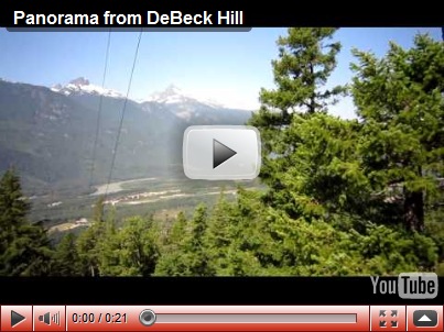
A panorama view from the top of DeBecks Hill.
After stopping for a drink and look at the view we descend the DeBeck Hill trail, passing some of the old machinery from the rail logging that was carried out in the early part of the century.

There are four lakes in Alice Lake Provincial Park. The largest is the parks namesake, Alice Lake and very much dedicated to family enjoyment, swimming, bathing jetties and pontoons, camping etc. Dogs are not allowed in Alice Lake but they are allowed throughout the rest of the park including the three other lakes.
Heading for Four Lakes Trail, we get these views of Alice Lake as we pass.


This is part of South Beach.

We start on the Four Lakes Trail which takes us through a mix of new and old-growth forest. Some of the huge stumps left a testament to how impressive the forest would have been one hundred years ago.

Mojo stops to refuel in a creek.

We reach the second of the lake (the first strictly speaking being Alice Lake where we set off). This one is called Edith Lake. It had only limited points of access and there were mostly 1ft or so drops from the bank into the water. While Mojo loves being in the lake he’s not prepared to jump into the water, favouring a sloped beach type walk in. We enjoy the views nonetheless.

I was also happy Mojo didn’t get in when I saw there were swarms of tadpoles in the area and knowing how much water Mojo takes in while he’s swimming I imagined these things wiggling around inside him if he’d got in here !

After Edith Lake the trail continues still mostly on old logging routes. Once away from Alice Lake the park is very peaceful and quiet. Not many other users of the trails so given it is mid-summer we keep a watchful eye for wildlife such as bears which will wander through the park this time of year. Thankfully we don’t meet any on this visit.
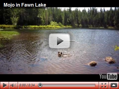
 After another couple of km we reach Fawn Lake. This was the most beautiful and serene of the four lakes (well, that is until Mojo launched himself into it)

There were absolutely no other people around, just me, Mojo, a few tweeting birds and plenty of dragon flies. A lovely peaceful place to stop and have lunch.

The easy sandy access into the lake meant Mojo was quick to get in and swam and fetched stick to his hearts content.
After lunch we head on further along the Four Lakes Trail. Shortly after Fawn Lake the trail diverts away from the logging routes onto smaller, more rooty trails through the forest.
Eventually it reaches the Cheekeye River which offers beautiful views West towards peaks in the Tantalus Range.
 The riverbed was easy to walk around on as the flow was so low this time of year.
 Forests to provide unlimited sticks, beautiful calm lakes to swim in and clean fresh rivers to drink from. Mojo thinks the BC Tourism slogan of ‘The Best Place on Earth’ is quite appropriate right now !
 Posing nicely for a headshot in the Cheekeye Riverbed.

The view upstream.
 A panorama view of the Cheekeye River.

We continue on along the Four Lakes Trail which eventually brings us out to Stump Lake. There are two routes around the lake, we took the shorter as we had more limited time and needed to get back to North Vancouver as we were going out later that evening. I think the longer route is supposed to provide better views of Stump Lake as you get the Garibaldi Mountain range in the background. I’ll try that route another time.
These however are the views on the shorter route around the lake.


We finish the trail and return to the car parked next to Alice Lake.
On our way home we stop at a view point on the highway just South of Squamish. This view back towards the town, The Chief seen clearly on the right.

On our way home we pull into Porteau Cove to take in the views of Howe Sound. This is the view south, it’s a little hazy as smoke from forest fires in the interior has started to blow into our area.

Looking North up Howe Sound.

This is the view North West.

And looking West towards Tetrahedron Provincial Park on the Sunshine Coast.

The old ferry ramp, still maintained incase of emergencies such as the Sea-to-Sky Highway becoming very damaged in the event of a landslide or earthquake.

Looking South-East along the coastline.

Finally a panorama view from Porteau Cove.

A really lovely day out in an easily accessible and attractive park with a beautiful drive there and back !
No comments:
Post a Comment